In a world where understanding our environment is more crucial than ever, the unveiling of a comprehensive geological map promises to be a game-changer. The Cooperative National Geologic Map by the United States Geological Survey (USGS) not only enriches our knowledge of the earth beneath us but also empowers communities to make informed decisions about their land. Let’s dive deeper into this groundbreaking resource and explore its significance.
Understanding the Cooperative National Geologic Map
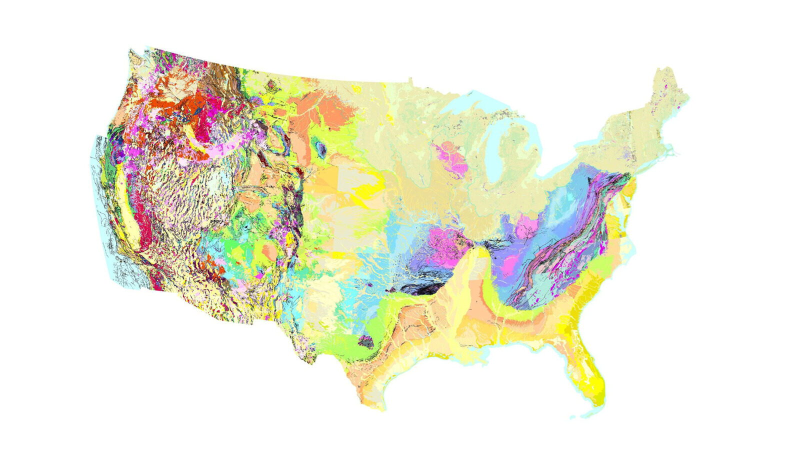
In August, the USGS released the Cooperative National Geologic Map, marking a significant advancement in geological mapping. This interactive map covers the geological composition of the contiguous United States with unprecedented detail. By integrating and synthesizing data from various sources, this map enhances our understanding of regional geology, making it accessible for a broad audience.
Previously, geological maps required extensive time and effort to compile. With ongoing discoveries and evolving surveys, data often became outdated before the project was completed. The new map addresses these challenges by using modern software that allows for the rapid integration of incoming geological data, ensuring that the information is current and relevant.
Over 100 smaller geological maps have been combined from a vast database of more than 27,000 records, resulting in a cohesive and visually appealing national map. This resource is invaluable not only for professionals in geology but also for students, educators, and anyone with an interest in understanding the earth beneath their feet.
The Importance of Geological Mapping
Geology is much more than just a study of rocks; it plays a vital role in public safety and environmental management. The data derived from geological surveys is crucial for various applications, such as:
- Assessing Earthquake Risks: Understanding the geological makeup helps identify areas vulnerable to seismic activity.
- Infrastructure Planning: Accurate geological data informs the design and placement of buildings, bridges, and roads.
- Groundwater Monitoring: Knowledge of geological formations aids in managing and protecting water resources.
- Hazard Identification: Geologists can pinpoint potential hazards, such as landslides or sinkholes, based on geological conditions.
- Resource Management: Mapping assists in identifying locations for natural resources, from minerals to fossil fuels.
With the Cooperative National Geologic Map, communities are better equipped to scrutinize geological assessments, ensuring that projects like pipelines and construction are safe for residents.
Navigating the Cooperative National Geologic Map
Using the Cooperative National Geologic Map is straightforward and user-friendly. Upon accessing the map in a web browser, users can navigate it similarly to other popular mapping platforms, such as Google Earth. Here are some key features that enhance the user experience:
- Zoom Functionality: Users can zoom in to examine specific areas in detail, helping to uncover local geological features.
- Waypoint Markers: Clicking on a particular location places a waypoint marker, making it easy to return to areas of interest.
- Search Bar: Quickly locate towns, counties, or notable landmarks by typing in the search function.
- Overlay Options: Various overlays, such as topography and satellite images, provide different perspectives on the geological landscape.
Decoding the Geological Layers
One of the standout features of the Cooperative National Geologic Map is its intuitive color key, which follows the conventions established by the National Geologic Map Database. This key allows users to easily distinguish between different geological layers based on their composition and age:
- Bedrock: Shown in grey, indicating solid rock beneath the surface.
- Dune Sand: Stabilized dunes are represented in yellow-green, highlighting areas shaped by wind action.
- Metamorphic Deposits: These appear in amber, indicating their formation during the Holocene epoch, our current geological period.
This clear classification helps users understand the geological history and composition of their local environment. By clicking on a specific area of interest, users can access detailed reports that informed the mapping of that zone.
 Uninhabited Islands: Exploring Worlds Without People
Accessing Geological Reports
Once you’ve pinpointed an area to explore on the map, the real advantage unfolds in the left-hand panel. This section provides direct links to all geological survey reports that contributed to the mapping of that specific region. For instance, selecting a prominent feature like Mount Rainier reveals links to 25 geological records sourced from the National Geologic Map Database. These records range from contemporary studies conducted in 2025 to historical surveys dating back to the 1800s.
This feature allows users to delve deeper into the geological history of significant landmarks, ensuring that the public can make informed decisions based on scientifically documented data. For example, a colorful survey from 1964 provides a cross-section view of Mount Rainier, illustrating the geological formations that characterize this majestic volcano.
The Future of Geological Mapping
The Cooperative National Geologic Map represents a significant leap forward in the field of geology. As technology continues to advance, we can expect even more dynamic and interactive geological resources to emerge. Future updates to the map could include:
- Real-Time Data Integration: Continuous input of new geological data to keep the map current.
- User Contributions: Allowing citizens and local geologists to contribute findings, enhancing community engagement.
- Enhanced Visualizations: Incorporating 3D models for a more immersive understanding of geological formations.
- Mobile Accessibility: Optimizing the map for mobile devices to reach a wider audience.
Through these advancements, the map can evolve into an even more powerful tool for education, research, and community planning, fostering a deeper connection between people and their geological surroundings.